

국립생태원에서 제공하는 수많은 자료를 e-Book으로 볼 수 있습니다.
통합검색
-
제목 : (제3차) 습지보호지역 정밀조사(’19). Ⅰ
발행일 : 2019-01-01 | 조회수 : 21992
카테고리 :
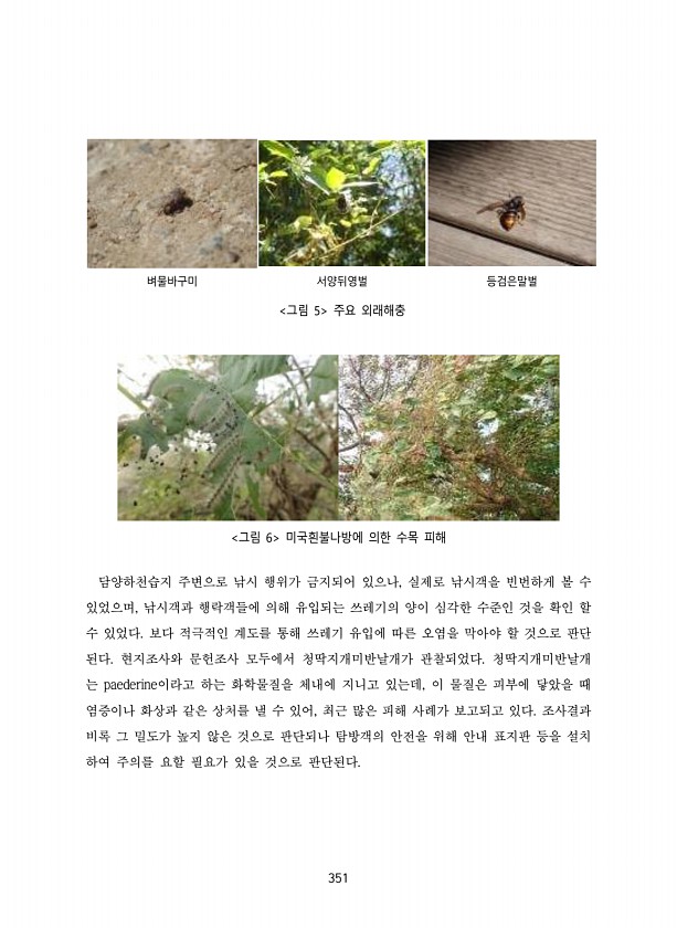
351 벼물바구미 서양뒤영벌 등검은말벌 그림 5 주요 외래해충 그림 6 미국흰불나방에 의한 수목 피해 담양하천습지 주변으로 낚시 행위가 금지되어 있으나, 실제로 낚시객을 빈번하게 볼 수 있었으며, 낚시객과 행락객들에 의해 유입되는 쓰레기의 양이 심각한 수준인 것을 확인 할 수 있었다. 보다 적극적인 계도를 통해 쓰레기 유입에 따른 오염을 막아야 할 것으로 판단 된다. 현지조사와 문헌조사 모두에서 청딱지개미반날개가 관찰되었다. 청딱지개미반날개 는 paederine이라고 하는 화학물질을 체내에 지니고 있는데, 이 물질은 피부에 닿았을 때 염증이나 화상과 같은 상처를 낼 수 있어, 최근 많은 피해 사례가 보고되고 있다. 조사결과 비록 그 밀도가 높지 않은 것으로 판단되나 탐방객의 안전을 위해 안내 표지판 등을 설...
-
-
제목 : (2018) 백두대간보호지역 생태계 조사.댓재~삽당령
발행일 : 2018-01-01 | 조회수 : 16640
카테고리 :
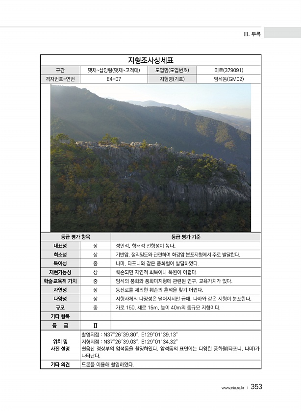
Ⅲ. 부록 www.nie.re.kr ? 353 지형조사상세표 구간 댓재삽당령 댓재고적대 도엽명 도엽번호 미로 379091 격자번호-연번 E4-07 지형명 기호 암석돔 GM02 등급 평가 항목 등급 평가 기준 대표성 상 성인적, 형태적 전형성이 높다. 희소성 상 기반암, 절리밀도와 관련하여 화강암 분포지형에서 주로 발달한다. 특이성 중 나마, 타포니와 같은 풍화혈이 발달하였다. 재현가능성 상 훼손되면 자연적 회복이나 복원이 어렵다. 학술?교육적 가치 중 암석의 풍화와 풍화미지형에 관련된 연구, 교육가치가 있다. 자연성 상 등산로를 제외한 훼손의 흔적을 찾기 어렵다. 다양성 상 지형자체의 다양성은 떨어지지만 급애, 나마와 같은 지형이 분포한다. 규모 중 가로 150, 세로 15m, 높이 40m의 중규모 지형이다...
-
제목 : (2018) 백두대간보호지역 생태계 조사.삽당령~신배령
발행일 : 2018-01-01 | 조회수 : 15077
카테고리 :
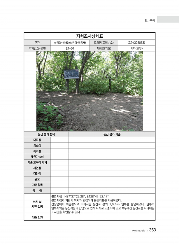
Ⅲ. 부록 www.nie.re.kr ? 353 지형조사상세표 구간 삽당령신배령 삽당령닭목재 도엽명 도엽번호 고단 378083 격자번호-연번 E1-01 지형명 기호 기타 안부 등급 평가 항목 등급 평가 기준 대표성 희소성 특이성 재현가능성 학술?교육적 가치 자연성 다양성 규모 기타 항목 등 급 위치 및 사진 설명 촬영지점 N37°37′29.28″, E128°47′22.17″ 촬영지점과 지형의 위치가 인접하여 동일좌표를 사용하였다. 삽당령에서 화란봉으로 이어지는 등산로 상의 1,055m 안부를 촬영하였다. 안부의 일부지역은 등산객들의 답압으로 인해 나지로 노출되어 있고 백두대간 등산로를 나타내는 표지판을 확인할 수 있다. 기타의견
-
제목 : (제4차) 전국내륙습지 정밀조사(’19)
발행일 : 2019-01-01 | 조회수 : 15491
카테고리 :
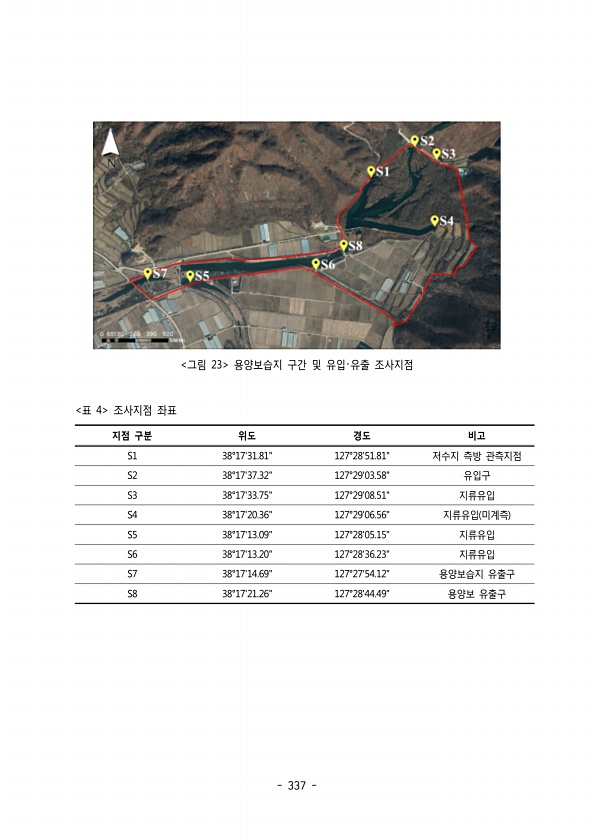
337 그림 23 용양보습지 구간 및 유입 유출 조사지점 ? 지점 구분 위도 경도 비고 S1 38°1731.81127°2851.81저수지 측방 관측지점 S2 38°1737.32127°2903.58유입구 S3 38°1733.75127°2908.51지류유입 S4 38°1720.36127°2906.56지류유입 미계측 S5 38°1713.09127°2805.15지류유입 S6 38°1713.20127°2836.23지류유입 S7 38°1714.69127°2754.12용양보습지 유출구 S8 38°1721.26127°2844.49용양보 유출구 표 4 조사지점좌표